Elevation Photos & Certificates

Elevation Certificate Services
Elevation photos capture visual documentation of a property’s elevation in relation to the ground level, neighboring structures, and potential flood lines. These photos are crucial for assessing the property’s vulnerability to flooding and for determining compliance with floodplain management regulations. Elevation certificates, on the other hand, are official documents issued by licensed surveyors that provide detailed information about a property’s elevation, including its location, flood zone, and base flood elevation. These certificates are often required for obtaining flood insurance, securing building permits, or complying with zoning and building regulations.The Elevation Certificate is a document from the National Flood Insurance Program also known as (NFIP). This certificate is to provide elevation information necessary to ensure compliance with community floodplain management ordinances, to determine the proper insurance premium rate, and to support a request for a Letter of Map Amendment (LOMA) or Letter of Map Revision based on fill (LOMR-F).
Latest Elevation Certification Work

Elevation Certification Tips

How Condo Inspections Differ From Single Home Inspections…
Purchasing a new home is an exciting milestone, but the process can also be overwhelming, especially when it comes to navigating the inspection process. While many people are familiar with the standard home inspection, the unique nature of condominium living requires...
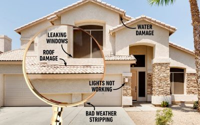
10 Reasons Why To Get a Professional Home Inspection Before Buying or Selling Property…
When it comes to purchasing a home, there are countless factors to consider. From location and price to layout and amenities, it's easy to become overwhelmed with choices. However, there's one critical step in the home buying process that should never be overlooked:...