 Navigating the complexities of property ownership can be a daunting task, especially when it comes to understanding the importance of elevation certificates. These unassuming documents play a crucial role in determining flood risk, compliance with local regulations, and the cost of flood insurance. Whether you’re a homeowner, real estate professional, or simply curious about the topic, this comprehensive guide will shed light on the intricacies of elevation certificates and their impact on your property.
Understanding Elevation Certificates
An elevation certificate is a document created by licensed land surveyors that provides detailed information about a property’s location, elevation, and flood risk. This data is collected in accordance with guidelines set forth by the Federal Emergency Management Agency (FEMA), the agency responsible for administering the National Flood Insurance Program (NFIP).
At the heart of an elevation certificate lies the property’s First Floor Elevation (FFE), which represents the height of the lowest floor relative to the surrounding grade. This critical measurement is then compared to the Base Flood Elevation (BFE) – the water level expected during a 1% annual chance flood event, also known as the “100-year flood.” By understanding the relationship between a property’s FFE and the BFE, insurance providers and local authorities can assess the property’s flood risk and make informed decisions about floodplain management and insurance coverage.
Identifying Flood Risk: The Role of Elevation Certificates
Determining a property’s flood risk is a complex process that takes into account numerous factors, including proximity to water sources, building characteristics, and past flood claims. Elevation certificates play a pivotal role in this assessment by providing precise data on a property’s elevation relative to the surrounding flood zones.
FEMA’s flood maps, which delineate areas of high, moderate, and low flood risk, serve as the foundation for this analysis. However, these maps often lack the granular detail necessary to accurately evaluate individual properties. This is where elevation certificates come into play, offering a more property-specific assessment of flood risk.
By comparing a property’s FFE to the BFE, elevation certificates can indicate the likelihood of a structure being inundated during a flood event. Structures with an FFE above the BFE are generally considered to have a lower risk of flood damage, while those with an FFE below the BFE face a higher probability of experiencing flood-related losses.
The Importance of Elevation Certificates for Flood Insurance
Flood insurance is a critical safeguard for property owners, particularly those located in high-risk flood zones. However, obtaining flood insurance coverage is often contingent on the availability of a valid elevation certificate.
FEMA’s NFIP requires policyholders in high-risk flood zones to provide an elevation certificate before a flood insurance policy can be issued. This document serves as the foundation for determining the appropriate insurance rates, as it allows insurers to accurately assess the property’s flood risk and tailor the coverage accordingly.
Homeowners who fail to obtain an elevation certificate may face significant challenges in securing flood insurance or may be subject to higher premiums. Conversely, properties with an FFE well above the BFE can often benefit from lower insurance rates, as the risk of flood-related losses is reduced.
Elevation Certificates and Floodplain Management
Elevation certificates play a crucial role in ensuring compliance with local, state, and federal floodplain management regulations. These regulations, which are often a prerequisite for participation in the NFIP, aim to minimize the impact of flooding on communities by establishing guidelines for new construction and substantial improvements to existing structures.
Communities that meet or exceed the minimum floodplain management standards set by FEMA are eligible for the Community Rating System (CRS) program. This voluntary initiative offers discounts on flood insurance premiums to policyholders, with the level of discount directly correlated to the community’s commitment to flood risk reduction measures.
Elevation certificates are a key component of the CRS program, as they provide the necessary data to verify that new buildings and substantial improvements in high-risk flood areas are properly elevated. By maintaining accurate elevation records, communities can demonstrate their compliance with floodplain management regulations and earn CRS discounts for their residents.
Navigating the Process of Obtaining an Elevation Certificate
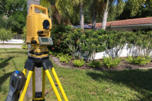
Obtaining an elevation certificate can be a straightforward process, but it requires the expertise of a licensed land surveyor. These professionals are trained to assess a property’s elevation, identify its flood zone, and compile the necessary information into the official FEMA-approved certificate.
There are several avenues to pursue when seeking an elevation certificate:
- Community Floodplain Managers: Many NFIP-participating communities have a designated floodplain manager who may be able to provide an existing elevation certificate or assist in obtaining a new one, especially if the community is enrolled in the CRS program.
- Previous Property Owners: When purchasing a property, it’s worth asking the sellers if they have a copy of the existing elevation certificate. This can save time and money, as long as no significant changes have been made to the property since the certificate was issued.
- Licensed Land Surveyors: If an elevation certificate is not readily available, property owners can hire a licensed land surveyor to conduct a new assessment and generate the necessary documentation. These professionals are authorized by law to certify elevation information and can provide the completed certificate within a matter of days.
- FEMA’s Online Elevation Certificate: FEMA offers a fillable elevation certificate form that property owners can complete themselves to self-certify their FFE. This option may be suitable for those in low-to-moderate risk flood zones, but it’s important to ensure the information is accurate and properly documented.
Elevation Certificates and Community Participation in the NFIP
The National Flood Insurance Program (NFIP) is a federal initiative that aims to reduce the impact of flooding on private and public structures. Participation in the NFIP is a critical component of effective floodplain management, as it provides access to federally-backed flood insurance and establishes guidelines for new construction and substantial improvements in high-risk areas.
Communities that participate in the NFIP are required to maintain accurate records of elevation data, often using elevation certificates to demonstrate compliance with local, state, and federal regulations. This information is essential for ensuring that new buildings and substantial improvements are properly elevated, mitigating the risk of flood-related damage.
Moreover, NFIP-participating communities that go above and beyond the minimum floodplain management standards can earn discounts through the Community Rating System (CRS) program. By implementing additional flood risk reduction measures and maintaining comprehensive elevation data, these communities can secure lower flood insurance premiums for their residents, providing a tangible financial incentive for prioritizing floodplain management.
The Impact of Elevation Certificates on Flood Insurance Premiums
Elevation certificates play a crucial role in determining the cost of flood insurance premiums for property owners. By providing detailed information about a property’s flood risk, these documents allow insurance providers to tailor coverage and rates to the specific characteristics of the insured structure.
Properties with an FFE well above the BFE generally face a lower risk of flood-related losses, and as a result, their flood insurance premiums are typically lower. Conversely, structures with an FFE below the BFE are considered to have a higher probability of experiencing flood damage, leading to higher insurance costs.
It’s important to note that the discount offered for properties with an FFE above the BFE is not a one-size-fits-all solution. The exact percentage of the discount can vary based on factors such as the property’s foundation type, the application of expense and loss constants, and the specific insurance provider’s underwriting guidelines.
To ensure that property owners are receiving the most favorable rates, it’s recommended to review the Discount Explanation Guide provided by FEMA or to consult directly with their insurance agent or carrier. By understanding the impact of elevation certificates on flood insurance premiums, homeowners can make informed decisions about mitigating their flood risk and potentially reducing their insurance costs.
Elevation Certificates and Map Changes
Flood maps, which delineate the boundaries of high-risk flood zones, are subject to periodic updates and revisions by FEMA. These changes can have significant implications for property owners, affecting their flood insurance requirements and premiums.
When a flood map is updated, property owners may need to obtain a new elevation certificate to reflect the changes in their property’s flood risk designation. This process, known as a Letter of Map Change (LOMC), involves submitting the elevation certificate along with other supporting documentation to FEMA for review and approval.
The LOMC process can be crucial for property owners seeking to have their properties removed from high-risk flood zones or to obtain a more accurate assessment of their flood risk. By providing detailed elevation data, homeowners can demonstrate that their structures are at a lower risk of flooding than indicated by the updated flood maps, potentially leading to lower insurance premiums or the removal of mandatory flood insurance requirements.
Elevation Certificates and Mitigation Efforts
Elevation certificates not only serve as a tool for assessing flood risk and determining insurance rates, but they also play a vital role in guiding mitigation efforts to reduce a property’s vulnerability to flooding.
By understanding the relationship between a property’s FFE and the BFE, homeowners can make informed decisions about elevating their structures, installing flood openings, or raising utilities to mitigate the impact of future flood events. These mitigation strategies can not only reduce the financial burden of flood-related losses but also contribute to lower flood insurance premiums over the long term.
FEMA’s Homeowners Guide to Retrofitting and the Mitigation Best Practices webpage offer valuable resources for property owners seeking to implement effective flood mitigation measures. By leveraging the information provided in their elevation certificates, homeowners can work with licensed professionals to identify and implement the most appropriate strategies for their specific properties.
Elevation Certificates and the Community Rating System (CRS)
The Community Rating System (CRS) is a voluntary program administered by FEMA that encourages communities to go above and beyond the minimum floodplain management standards set by the NFIP. By implementing additional flood risk reduction measures, CRS-participating communities can earn discounts on flood insurance premiums for their residents.
Elevation certificates play a crucial role in the CRS program, as they provide the necessary data to verify that new buildings and substantial improvements in high-risk flood areas are properly elevated. Communities that use the FEMA Elevation Certificate and maintain comprehensive elevation records can demonstrate their commitment to floodplain management and earn higher CRS discounts.
By participating in the CRS program and leveraging the information provided by elevation certificates, communities can create a safer and more flood-resilient environment for their residents. This, in turn, can lead to lower insurance costs, reduced disaster-related suffering, and a stronger overall defense against the devastating impacts of flooding.
Elevation Certificates and Property Transactions
Elevation certificates can also be an essential consideration during real estate transactions, particularly when buying or selling a property located in a high-risk flood zone.
When purchasing a property, it’s crucial for prospective buyers to request and review the existing elevation certificate. This document can provide valuable insights into the property’s flood risk, the cost of flood insurance, and any potential mitigation efforts that may be required to bring the structure into compliance with local regulations.
Similarly, sellers of properties in flood-prone areas should be prepared to provide a current elevation certificate to potential buyers. This can help facilitate the sale process, demonstrate the property’s flood risk, and ensure that the new owners are aware of the necessary steps to obtain appropriate flood insurance coverage.
Real estate professionals, such as agents and brokers, also play a vital role in educating their clients about the importance of elevation certificates. By understanding the impact of these documents on the buying and selling process, they can help their clients make informed decisions and navigate the complexities of flood risk management.
Elevation Certificates and Property Assessments
Elevation certificates can also be a critical tool in the property assessment process, particularly for structures located in high-risk flood zones. By providing detailed information about a property’s elevation and flood risk, these documents can help assessors accurately determine the value of the property and any potential impact on its market price.
In the event of a flood event, elevation certificates can also be used by insurance adjusters and disaster relief agencies to assess the extent of damage and the appropriate level of compensation or assistance. This information can be crucial in ensuring that property owners receive the support they need to recover and rebuild in the aftermath of a natural disaster.
Moreover, elevation certificates can be used by local authorities and community planners to identify areas of high flood risk and prioritize infrastructure improvements or mitigation efforts. By leveraging this data, decision-makers can make more informed choices about the allocation of resources and the implementation of flood-resilient policies.
Elevation certificates are a powerful tool in the world of property management, flood risk assessment, and disaster preparedness. These unassuming documents hold the key to understanding a property’s vulnerability to flooding, compliance with local regulations, and the cost of flood insurance coverage.
Contact Us (954-909-1255) For a Free Consultation!
—
 About Major League Inspections
Our home inspections involve thorough evaluations of residential properties to identify any issues, ensuring that buyers and sellers are well-informed about the property’s condition. Our commercial inspections focus on assessing the structural integrity, safety features, and compliance of commercial properties with building codes and regulations. Both types of inspections are crucial for promoting safety and informed decision-making. Our environmental inspection services address damage caused by water, fire, mold, and other disasters. When you experience environmental damage, it’s crucial to conduct a thorough inspection first to identify any hidden issues that could lead to problems in the future and help a restoration team properly restore your property.
> Learn More